
Washington topographic map
Interactive map
Click on the map to display elevation.
About this map
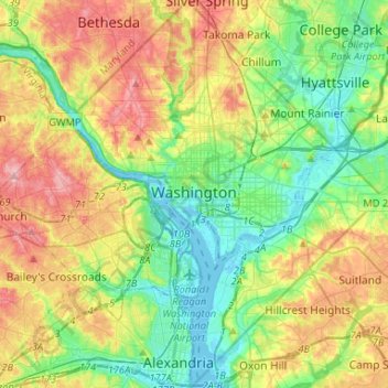
Name: Washington topographic map, elevation, terrain.
Location: Washington, District of Columbia, Estados Unidos de América (38.79163 -77.11979 38.99597 -76.90937)
Average elevation: 52 m
Minimum elevation: -3 m
Maximum elevation: 138 m
Other topographic maps
Click on a map to view its topography, its elevation and its terrain.
Ward 5
Estados Unidos de América > District of Columbia > Washington
Ward 5, Washington, District of Columbia, Estados Unidos de América
Average elevation: 35 m