
Saratoga County topographic map
Interactive map
Click on the map to display elevation.
About this map
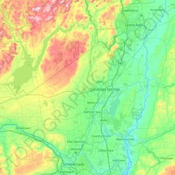
Name: Saratoga County topographic map, elevation, terrain.
Location: Saratoga County, New York, United States (42.77546 -74.16010 43.39797 -73.57327)
Average elevation: 218 m
Minimum elevation: 3 m
Maximum elevation: 833 m
Saratoga County is situated in the eastern portion of New York State, north of Albany, northwest of Troy, and east of Utica. According to the U.S. Census Bureau, the county has a total area of 844 square miles (2,190 km2), of which 810 square miles (2,100 km2) is land and 34 square miles (88 km2) (4.0%) is water. The Hudson River forms the eastern border of the county, while the Mohawk River demarcates its southern border. The highest elevation in Saratoga County is at the peak of Hadley Mountain in the Adirondack Mountains, at 2,675 feet (815 meters), while the lowest elevation is 69 feet (21 meters), at the waterfront of the Village of Waterford, at the confluence of the Mohawk and Hudson rivers.
Other topographic maps
Click on a map to view its topography, its elevation and its terrain.
Coram
United States > New York > Suffolk County > Town of Brookhaven
Coram, Town of Brookhaven, Suffolk County, New York, 11727, United States
Average elevation: 40 m
North Amityville
United States > New York > Suffolk County > Town of Babylon
North Amityville, Town of Babylon, Suffolk County, New York, United States
Average elevation: 15 m
Falls Lake
United States > New York > Herkimer County > Little Rapids
Falls Lake, Little Rapids, Town of Webb, Herkimer County, New York, United States
Average elevation: 520 m
Waverly Glen Park
United States > New York > Tioga County > Waverly
Waverly Glen Park, Waverly, Town of Barton, Tioga County, New York, United States
Average elevation: 295 m
Town of Woodstock
United States > New York > Ulster County
Town of Woodstock, Ulster County, New York, United States
Average elevation: 332 m
Village of Woodbury
United States > New York > Orange County
Village of Woodbury, Town of Woodbury, Orange County, New York, United States
Average elevation: 255 m
Village of Fleischmanns
United States > New York > Delaware County
Village of Fleischmanns, Town of Middletown, Delaware County, New York, United States
Average elevation: 553 m
Battery Park
United States > New York > New York County > New York
Battery Park, Manhattan Community Board 1, Manhattan, New York County, New York, 10004, United States
Average elevation: 3 m
West Islip
United States > New York > Suffolk County > Town of Islip
West Islip, Town of Islip, Suffolk County, New York, 11795, United States
Average elevation: 7 m
Hill Cumorah
United States > New York > Ontario County > Town of Manchester
Hill Cumorah, Town of Manchester, Ontario County, New York, 14504, United States
Average elevation: 182 m
Village of Mexico
United States > New York > Oswego County
Village of Mexico, Town of Mexico, Oswego County, New York, 13114, United States
Average elevation: 117 m
Village of Massapequa Park
United States > New York > Nassau County
Village of Massapequa Park, Town of Oyster Bay, Nassau County, New York, 11762, United States
Average elevation: 9 m
Big Flats
United States > New York > Chemung County
Big Flats, Town of Big Flats, Chemung County, New York, 14814, United States
Average elevation: 379 m
Colonial Heights
United States > New York > Dutchess County > MacDonnell Heights
Colonial Heights, MacDonnell Heights, Town of Poughkeepsie, Dutchess County, New York, 12603, United States
Average elevation: 77 m
Halfmoon Beach
United States > New York > Saratoga County > Town of Halfmoon
Halfmoon Beach, Town of Halfmoon, Saratoga County, New York, 12047, United States
Average elevation: 77 m
Village of Farmingdale
United States > New York > Nassau County
Village of Farmingdale, Town of Oyster Bay, Nassau County, New York, United States
Average elevation: 25 m
Little Island
United States > New York > New York County > New York
Little Island, Manhattan Community Board 2, Manhattan, New York County, New York, United States
Average elevation: 8 m
Village of Monticello
United States > New York > Sullivan County
Village of Monticello, Town of Thompson, Sullivan County, New York, United States
Average elevation: 444 m
East Aurora
United States > New York > Erie County > East Aurora
East Aurora, Town of Aurora, Erie County, New York, 14052, United States
Average elevation: 283 m
Lost Lake
United States > New York > Onondaga County > Town of Manlius
Lost Lake, Town of Manlius, Onondaga County, New York, United States
Average elevation: 206 m
Glenham
United States > New York > Dutchess County > Town of Fishkill
Glenham, Town of Fishkill, Dutchess County, New York, 12527, United States
Average elevation: 108 m
West Mount Vernon
United States > New York > Westchester County > Mount Vernon > West Mount Vernon
West Mount Vernon, Mount Vernon, Westchester County, New York, 10550, United States
Average elevation: 49 m
Syracuse
United States > New York > Onondaga County > Syracuse
Syracuse, Onondaga County, New York, United States
Average elevation: 172 m
Town of Tyrone
United States > New York > Schuyler County > Town of Tyrone
Town of Tyrone, Schuyler County, New York, 14887, United States
Average elevation: 421 m
City of Albany
United States > New York > Albany County
City of Albany, Albany County, New York, United States
Average elevation: 68 m
Town of Clay
United States > New York > Onondaga County > Town of Clay
Town of Clay, Onondaga County, New York, United States
Average elevation: 120 m
Niskayuna
United States > New York > Schenectady County > Niskayuna
Niskayuna, Schenectady County, New York, United States
Average elevation: 94 m
Mount Vernon
United States > New York > Westchester County > Mount Vernon
Mount Vernon, Westchester County, New York, United States
Average elevation: 41 m
Center Island
United States > New York > Centre Island
Center Island, Centre Island, Nassau County, New York, 11709, United States
Average elevation: 33 m
Governors Island
United States > New York > New York County > New York
Governors Island, Manhattan, New York County, New York, United States
Average elevation: 1 m
Brooklyn
United States > New York > New York
Brooklyn, Kings County, New York, United States
Average elevation: 10 m
Rye
United States > New York > Westchester > Rye
Rye, Westchester, New York, United States
Average elevation: 8 m
Niagara County
Niagara County, New York, United States
Average elevation: 111 m
Buffalo
United States > New York > Erie County > Buffalo
Buffalo, Erie County, New York, United States
Average elevation: 185 m
Parish
United States > New York > Parish
Parish, Town of Parish, Oswego County, New York, 13131, United States
Average elevation: 147 m
Arctic
United States > New York > Arctic
Arctic, Town of Masonville, Delaware County, New York, United States
Average elevation: 558 m
Rochester
United States > New York > Monroe County > Rochester
Rochester, Monroe County, New York, United States
Average elevation: 129 m
Staten Island
United States > New York > New York
Staten Island, New York, United States
Average elevation: 11 m
Niagara Falls
United States > New York > Niagara County > Niagara Falls
Niagara Falls, Niagara County, New York, United States
Average elevation: 180 m
Manhattan
United States > New York > New York County
Manhattan, New York County, New York, United States
Average elevation: 17 m
Suffolk County
Suffolk County, New York, United States
Average elevation: 34 m
New York County
United States > New York > New York
New York County, New York, United States
Average elevation: 16 m