
Dakshinkali topographic map
Interactive map
Click on the map to display elevation.
About this map
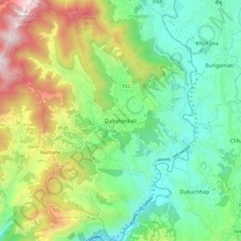
Name: Dakshinkali topographic map, elevation, terrain.
Average elevation: 1,611 m
Minimum elevation: 1,141 m
Maximum elevation: 2,530 m
Other topographic maps
Click on a map to view its topography, its elevation and its terrain.
Kathmandu
Nepal > Bagmati Province > Kathmandu
Kathmandu, Kathmandu Metropolitan City, Kathmandu, Bagmati Province, 46000, Nepal
Average elevation: 1,538 m