
Barrage Sidi El Barrak topographic map
Interactive map
Click on the map to display elevation.
About this map
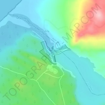
Name: Barrage Sidi El Barrak topographic map, elevation, terrain.
Location: Barrage Sidi El Barrak, Ezzouaraa, Nefza, Béja, Tunisie (37.02173 8.93004 37.02769 8.93966)
Average elevation: 48 m
Minimum elevation: -3 m
Maximum elevation: 183 m
Other topographic maps
Click on a map to view its topography, its elevation and its terrain.
Barrage Sidi Salem
Barrage Sidi Salem, Mezougha, Testour, Béja, Tunisie
Average elevation: 139 m
Téboursouk
Tunisie > Béja > Téboursouk
Téboursouk, Teboursouk Ville, Teboursouk, Béja, 9040, Tunisie
Average elevation: 402 m