
Sherpur District topographic map
Interactive map
Click on the map to display elevation.
About this map
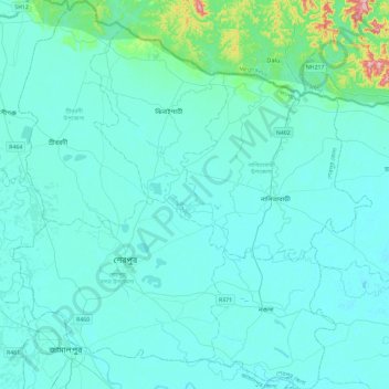
Name: Sherpur District topographic map, elevation, terrain.
Location: Sherpur District, Mymensingh Division, Bangladesh (24.88318 89.88102 25.30381 90.30962)
Average elevation: 27 m
Minimum elevation: 8 m
Maximum elevation: 240 m
Other topographic maps
Click on a map to view its topography, its elevation and its terrain.
Brahmaputra River
Bangladesh > Mymensingh Division > Jamalpur Sadar Upazila > Jamalpur
The course of the Brahmaputra River has changed drastically in the past two and a half centuries, moving its river course westwards for a distance of about 80 km (50 mi), leaving its old river course, appropriately named the old Brahmaputra river, behind. In the past, the floodplain of the old river course had…
Average elevation: 18 m