
Holmes County topographic map
Interactive map
Click on the map to display elevation.
About this map
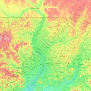
Name: Holmes County topographic map, elevation, terrain.
Location: Holmes County, Florida, VS (30.70298 -86.03777 30.99693 -85.49799)
Average elevation: 39 m
Minimum elevation: 3 m
Maximum elevation: 99 m
Other topographic maps
Click on a map to view its topography, its elevation and its terrain.
Presbyterian Villas Of Lehigh
VS > Florida > Presbyterian Villas Of Lehigh
Presbyterian Villas Of Lehigh, Lee County, Florida, 33936, VS
Average elevation: 10 m
Main Street, U.S.A.
Main Street, U.S.A., Bay Lake, Reedy Creek Improvement District, Orange County, Florida, VS
Average elevation: 30 m
Dry Tortugas National Park
Dry Tortugas National Park, Monroe County, Florida, VS
Average elevation: 0 m