
Col du Platzerwasel topographic map
Interactive map
Click on the map to display elevation.
About this map
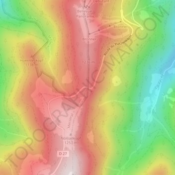
Name: Col du Platzerwasel topographic map, elevation, terrain.
Average elevation: 1,024 m
Minimum elevation: 683 m
Maximum elevation: 1,298 m
Le col du Platzerwasel est un col des Vosges, situé dans le Haut-Rhin, en France, à 1 182 mètres d'altitude.
Other topographic maps
Click on a map to view its topography, its elevation and its terrain.
Haut Mittlach
France > Grand Est > Haut-Rhin > Mittlach > Haut Mittlach
Haut Mittlach, Mittlach, Colmar-Ribeauvillé, Haut-Rhin, Grand Est, France métropolitaine, 68380, France
Average elevation: 857 m