
Hintertal topographic map
Interactive map
Click on the map to display elevation.
About this map
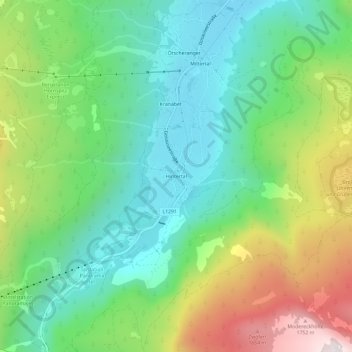
Name: Hintertal topographic map, elevation, terrain.
Location: Hintertal, Gosau, Bezirk Gmunden, 4824, Österreich (47.53493 13.49790 47.57493 13.53790)
Average elevation: 1,088 m
Minimum elevation: 727 m
Maximum elevation: 1,805 m
Other topographic maps
Click on a map to view its topography, its elevation and its terrain.
Großer Donnerkogel
Österreich > Bezirk Gmunden > Gosau
Großer Donnerkogel, Gosau, Bezirk Gmunden, 4824, Österreich
Average elevation: 1,442 m