
Thank you for supporting this site ❤️
Make a donation
Make a donation
Giverdy topographic map
Click on the map to display elevation.
Thank you for supporting this site ❤️
Make a donation
Make a donation
About this map
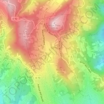
Name: Giverdy topographic map, elevation, terrain.
Average elevation: 450 m
Minimum elevation: 277 m
Maximum elevation: 605 m
Thank you for supporting this site ❤️
Make a donation
Make a donation
Other topographic maps
Click on a map to view its topography, its elevation and its terrain.
69370
France > Auvergne-Rhône-Alpes > Métropole de Lyon > Saint-Didier-au-Mont-d'Or
Average elevation: 323 m