
Make a donation
Holy Cross Voivodeship topographic map
Click on the map to display elevation.
Make a donation
About this map
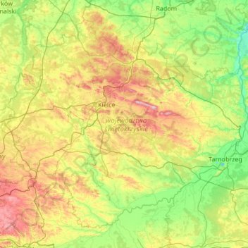
Name: Holy Cross Voivodeship topographic map, elevation, terrain.
Location: Holy Cross Voivodeship, Poland (50.18545 19.70430 51.34245 21.86926)
Average elevation: 229 m
Minimum elevation: 117 m
Maximum elevation: 601 m
Make a donation
Other topographic maps
Click on a map to view its topography, its elevation and its terrain.
Make a donation
Osiedle Młodych
Poland > Łódź Voivodeship > Poddębice County > Pęczniew > Osiedle Młodych
Average elevation: 123 m
Make a donation
Warsaw
Poland > Masovian Voivodeship > Warsaw > Warsaw
Warsaw lies in east-central Poland about 300 km (190 mi) from the Carpathian Mountains and about 260 km (160 mi) from the Baltic Sea, 523 km (325 mi) east of Berlin, Germany. The city straddles the Vistula River. It is located in the heartland of the Masovian Plain, and its average elevation is 100 m (330 ft)…
Average elevation: 95 m
Rolica
Poland > Lesser Poland Voivodeship > Wieliczka County > Wiatowice > Rolica
Average elevation: 256 m
Make a donation