
Thank you for supporting this site ❤️
Make a donation
Make a donation
Nevis topographic map
Click on the map to display elevation.
Thank you for supporting this site ❤️
Make a donation
Make a donation
Nevis
Seven volcanic centers make up Nevis. These include Round Hill (3.43 Ma), Cades Bay (3.22 Ma), Hurricane Hill (2.7 Ma), Saddle Hill (1.8 Ma), Butlers Mountain (1.1 Ma), Red Cliff and Nevis Peak (0.98 Ma). These are mainly andesite and dacite lava domes, with associated block and ash flows, plus lahars. Nevis Peak has the highest elevation, at 984 m. Cades Bay and Farm Estate Soufriere are noted areas of hydrothermal activity.
Thank you for supporting this site ❤️
Make a donation
Make a donation
About this map
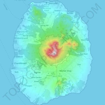
Name: Nevis topographic map, elevation, terrain.
Location: Nevis, Saint Kitts and Nevis (17.09417 -62.63353 17.20774 -62.53963)
Average elevation: 92 m
Minimum elevation: 0 m
Maximum elevation: 953 m
Thank you for supporting this site ❤️
Make a donation
Make a donation
Other topographic maps
Click on a map to view its topography, its elevation and its terrain.