
Mandla Tahsil topographic map
Interactive map
Click on the map to display elevation.
About this map
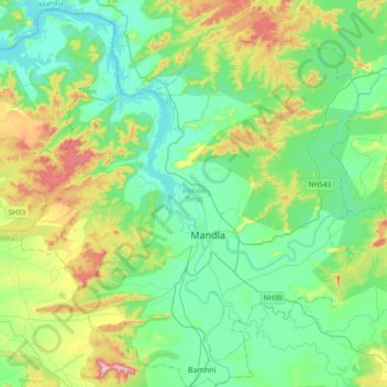
Name: Mandla Tahsil topographic map, elevation, terrain.
Location: Mandla Tahsil, Mandla, Madhya Pradesh, India (22.46071 80.19002 22.80900 80.54021)
Average elevation: 493 m
Minimum elevation: 410 m
Maximum elevation: 732 m
Other topographic maps
Click on a map to view its topography, its elevation and its terrain.
Kanha National Park
India > Madhya Pradesh > Mandla Tahsil > Mandla
Kanha National Park, Mandla, Mandla Tahsil, Mandla, Madhya Pradesh, 481665, India
Average elevation: 442 m