
Corbett Tiger Reserve topographic map
Interactive map
Click on the map to display elevation.
About this map
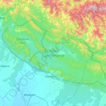
Name: Corbett Tiger Reserve topographic map, elevation, terrain.
Average elevation: 632 m
Minimum elevation: 221 m
Maximum elevation: 2,488 m
Other topographic maps
Click on a map to view its topography, its elevation and its terrain.
Dādāmandi
India > Uttarakhand > Kotdwara
Dādāmandi, Kotdwara, Pauri Garhwal District, Uttarakhand, 246124, India
Average elevation: 1,032 m
Ramganga Dam
India > Uttarakhand > Kotdwara
Ramganga Dam, Kotdwara, Pauri Garhwal, Uttarakhand, India
Average elevation: 389 m
Khundra
India > Uttarakhand > Kotdwara
Khundra, Kotdwara, Pauri Garhwal, Uttarakhand, India
Average elevation: 1,178 m
Kotdwar
India > Uttarakhand > Kotdwara
Kotdwar, Kotdwara, Pauri Garhwal District, Uttarakhand, 246149, India
Average elevation: 471 m
Kālāgarh
India > Uttarakhand > Kotdwara > Kālāgarh
Kālāgarh, Kotdwara, Pauri Garhwal, Uttarakhand, India
Average elevation: 331 m