
Thank you for supporting this site ❤️
Make a donation
Make a donation
Paseh topographic map
Click on the map to display elevation.
Thank you for supporting this site ❤️
Make a donation
Make a donation
About this map
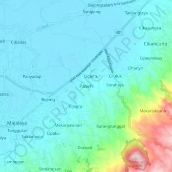
Name: Paseh topographic map, elevation, terrain.
Location: Paseh, Kabupaten Bandung, Java, 40383, Indonesia (-7.07248 107.75391 -6.99248 107.83391)
Average elevation: 739 m
Minimum elevation: 660 m
Maximum elevation: 1,182 m
Thank you for supporting this site ❤️
Make a donation
Make a donation
Other topographic maps
Click on a map to view its topography, its elevation and its terrain.