
Make a donation
Jayne's Hill topographic map
Click on the map to display elevation.
Make a donation
Jayne's Hill
Jayne's Hill (also known as High Hill, West Hills, Oakley's Hill, and Janes Hill) is the highest point on Long Island, New York, with an elevation of between 387 feet (118 m) and 400.9 feet (122.2 m) above sea level. It is situated on the Harbor Hill moraine, a terminal moraine that makes up the northern spine of Long Island. in West Hills County Park in Suffolk County, a little more than a mile to the north of Melville.
Make a donation
About this map
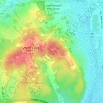
Name: Jayne's Hill topographic map, elevation, terrain.
Average elevation: 73 m
Minimum elevation: 43 m
Maximum elevation: 115 m
Make a donation
Other topographic maps
Click on a map to view its topography, its elevation and its terrain.
Cold Spring Harbor
United States > New York > Suffolk County > Town of Huntington > Cold Spring Harbor
Average elevation: 46 m
Halesite
United States > New York > Suffolk County > Town of Huntington > Halesite > Fort Hill
Average elevation: 31 m
Melville
United States > New York > Suffolk County > Town of Huntington
Long Island's highest point is Jayne's Hill in the neighboring hamlet of West Hills, with an elevation of 387 feet (118 m) to 400.9 feet (122.2 m) above sea level.
Average elevation: 53 m
Make a donation
Village of Lloyd Harbor
United States > New York > Suffolk County > Town of Huntington
Average elevation: 14 m
Cold Spring Harbor
United States > New York > Suffolk County > Town of Huntington > Cold Spring Harbor
Average elevation: 47 m
Make a donation
Melville
United States > New York > Suffolk County > Town of Huntington
Long Island's highest point is Jayne's Hill in the neighboring hamlet of West Hills, with an elevation of 387 feet (118 m) to 400.9 feet (122.2 m) above sea level.
Average elevation: 53 m
Huntington Station
United States > New York > Suffolk County > Town of Huntington
Average elevation: 60 m
Make a donation