
Thank you for supporting this site ❤️
Make a donation
Make a donation
New Tehri topographic map
Click on the map to display elevation.
Thank you for supporting this site ❤️
Make a donation
Make a donation
About this map
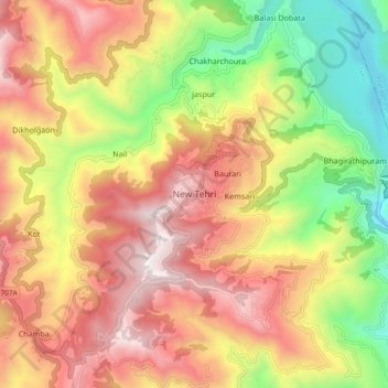
Name: New Tehri topographic map, elevation, terrain.
Location: New Tehri, Tehri, Tehri Garhwal, Uttarakhand, 249001, India (30.33445 78.39277 30.41445 78.47277)
Average elevation: 1,331 m
Minimum elevation: 610 m
Maximum elevation: 1,985 m
Thank you for supporting this site ❤️
Make a donation
Make a donation
Other topographic maps
Click on a map to view its topography, its elevation and its terrain.