
Jeju-do topographic map
Interactive map
Click on the map to display elevation.
About this map
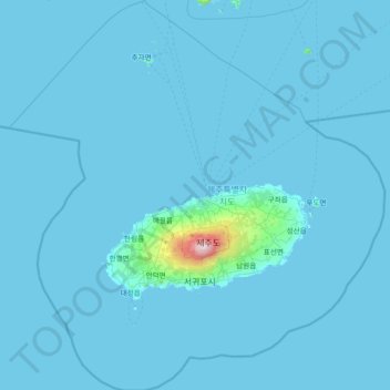
Name: Jeju-do topographic map, elevation, terrain.
Location: Jeju-do, South Korea (32.91046 125.79410 34.13981 127.21523)
Average elevation: 28 m
Minimum elevation: -1 m
Maximum elevation: 1,866 m
Other topographic maps
Click on a map to view its topography, its elevation and its terrain.
Jeju-si
South Korea > Jeju-do > Jeju-si
Jeju-si, Jeju, Jeju-do, 63183, South Korea
Average elevation: 263 m