
Nha Trang topographic map
Interactive map
Click on the map to display elevation.
About this map
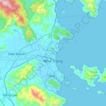
Name: Nha Trang topographic map, elevation, terrain.
Location: Nha Trang, Khánh Hoà Province, Vietnam (12.14288 109.11288 12.37991 109.37148)
Average elevation: 118 m
Minimum elevation: -2 m
Maximum elevation: 1,315 m
Other topographic maps
Click on a map to view its topography, its elevation and its terrain.
Nha Trang
Vietnam > Khanh Hoa province > Nha Trang
Nha Trang, Khanh Hoa province, 48058, Vietnam
Average elevation: 113 m