
Mitte topographic map
Interactive map
Click on the map to display elevation.
About this map
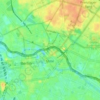
Name: Mitte topographic map, elevation, terrain.
Location: Mitte, Berlijn, Duitsland (52.50404 13.36586 52.54040 13.42940)
Average elevation: 44 m
Minimum elevation: 29 m
Maximum elevation: 63 m
Other topographic maps
Click on a map to view its topography, its elevation and its terrain.
Siemensstadt
Siemensstadt, Spandau, Berlijn, 13629, Duitsland
Average elevation: 35 m
Charlottenburg-Wilmersdorf
Charlottenburg-Wilmersdorf, Berlijn, Duitsland
Average elevation: 44 m
Lichterfelde
Lichterfelde, Steglitz-Zehlendorf, Berlijn, Duitsland
Average elevation: 47 m