
Thank you for supporting this site ❤️
Make a donation
Make a donation
Kotra topographic map
Click on the map to display elevation.
Thank you for supporting this site ❤️
Make a donation
Make a donation
About this map
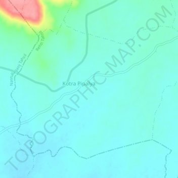
Name: Kotra topographic map, elevation, terrain.
Location: Kotra, Rehti Tahsil, Sehore District, Madhya Pradesh, India (22.76170 77.31686 22.78842 77.35400)
Average elevation: 318 m
Minimum elevation: 302 m
Maximum elevation: 400 m
Thank you for supporting this site ❤️
Make a donation
Make a donation
Other topographic maps
Click on a map to view its topography, its elevation and its terrain.
Rehti
India > Madhya Pradesh > Rehti Tahsil
Rehti is located at 22°44′N 77°26′E / 22.73°N 77.43°E / 22.73; 77.43. It has an average elevation of 303 metres (994 feet). It is located near Vindhyachal Range and surrounded by mountains. The nearest airport is Bhopal and the nearest railway station is Hoshangabad, 37 km away.
Average elevation: 306 m