
Tan Binh District topographic map
Interactive map
Click on the map to display elevation.
About this map
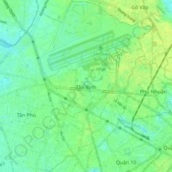
Name: Tan Binh District topographic map, elevation, terrain.
Location: Tan Binh District, Ho Chi Minh City, Vietnam (10.76884 106.62791 10.83730 106.67858)
Average elevation: 9 m
Minimum elevation: 2 m
Maximum elevation: 16 m
Other topographic maps
Click on a map to view its topography, its elevation and its terrain.
Ho Chi Minh City
Ho Chi Minh City is located in the south-eastern region of Vietnam, 1,760 km (1,090 mi) south of Hanoi. The average elevation is 5 metres (16 ft) above sea level for the city center and 16 metres (52 ft) for the suburb areas. It borders Tây Ninh Province and Bình Dương Province to the north, Đồng Nai…
Average elevation: 6 m