
Make a donation
Sanda topographic map
Click on the map to display elevation.
Make a donation
Sanda
Sanda City is located in southeast Hyōgo Prefecture, about 25 kilometres (16 mi) to the north of the city of Kobe beyond the Rokkō Mountains and about 35 kilometres (22 mi) northwest of the city of Osaka. The highest elevation point in the city is 697 metres (2,287 ft) at Mt. Mine, and the lowest elevation point is 116 metres (381 ft). The northern and eastern parts of the city are mountainous. In the past, it had the appearance of a typical farming village with rural scenery, but due to the development of large-scale housing complexes since the 1980s and the convenience of double-track electrification of the JR Fukuchiyama Line, it has rapidly become a satellite city of Osaka and Kobe.
Make a donation
About this map
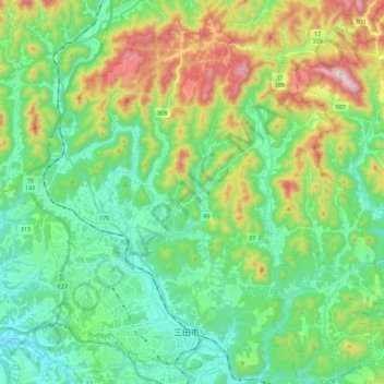
Name: Sanda topographic map, elevation, terrain.
Location: Sanda, Hyogo Prefecture, Japan (34.87244 135.09250 35.03709 135.31037)
Average elevation: 290 m
Minimum elevation: 105 m
Maximum elevation: 734 m
Make a donation
Other topographic maps
Click on a map to view its topography, its elevation and its terrain.
Mount Fuji
Japan > Sunto County > Oyama
Mount Fuji (富士山, Fujisan, Japanese: [ɸɯꜜ(d)ʑisaɴ] (listen)), or Fugaku, located on the island of Honshū, is the highest mountain in Japan, with a summit elevation of 3,776.24 m (12,389 ft 3 in). It is the second-highest volcano located on an island in Asia (after Mount Kerinci on the island of…
Average elevation: 3,264 m
Mount Fuji
Japan > Sunto County > Oyama
Mount Fuji (富士山, Fujisan, Japanese: [ɸɯꜜ(d)ʑisaɴ] (listen)), or Fugaku, located on the island of Honshū, is the highest mountain in Japan, with a summit elevation of 3,776.24 m (12,389 ft 3 in). It is the second-highest volcano located on an island in Asia (after Mount Kerinci on the island of…
Average elevation: 3,261 m
Make a donation
Make a donation
Mount Aso
Japan > Aso County > Minamiaso
With an elevation of 1,143 metres (3,750 ft)., Mount Aso has a climate that falls as humid continental (Köppen climate classification "Dfb"), with warm summers and cold winters. Precipitation is high throughout the year, which brings the area to have borderline subtropical characteristics as well. It is…
Average elevation: 1,254 m
Make a donation
Mount Fuji
Japan > Sunto County > Oyama
Mount Fuji (富士山・富士の山, Fujisan, Fuji no Yama) is an active stratovolcano located on the Japanese island of Honshu, with a summit elevation of 3,776.24 m (12,389 ft 3 in). It is the highest mountain in Japan, the second-highest volcano on any Asian island (after Mount Kerinci on the Indonesian…
Average elevation: 3,264 m
Mount Tateshina
It has an elevation of 2,530 m (8,301 ft). This mountain is one of the 100 Famous Japanese Mountains.
Average elevation: 2,082 m
Make a donation
Make a donation
Make a donation
Make a donation
Make a donation
Make a donation
Shirakawa
Shirakawa is a mountain village located in far northern Gifu Prefecture, bordering Ishikawa Prefecture and Toyama Prefecture on the Ryōhaku Mountains. Mount Hakusan is the highest elevation at 2,172 metres (7,126 ft). The village's area is 95.7% mountainous forests, and its steep places are characteristic. In…
Average elevation: 667 m
Make a donation
Make a donation
Mount Fuji
Japan > Sunto County > Oyama
Mount Fuji (富士山・富士の山, Fujisan, Fuji no Yama) is an active stratovolcano located on the Japanese island of Honshu, with a summit elevation of 3,776.24 m (12,389 ft 3 in). It is the highest mountain in Japan, the second-highest volcano on any Asian island (after Mount Kerinci on the Indonesian…
Average elevation: 3,261 m
Make a donation
Make a donation
Mount Chōkai
Japan > Akumi County > Yuza
Mount Chōkai is shared by two municipalities in Akita Prefecture and four municipalities Yamagata Prefecture; however, its peak is located in Yuza, on the Yamagata side of the border. It is therefore the highest peak in Yamagata, and the second highest in the Tōhoku region after Mt. Hiuchigatake (altitude…
Average elevation: 1,808 m
Make a donation
Make a donation
Make a donation
Mount Fuji
Japan > Sunto County > Oyama
Mount Fuji (富士山, Fujisan, Japanese: [ɸɯꜜ(d)ʑisaɴ] ) is an active stratovolcano located on the Japanese island of Honshu, with a summit elevation of 3,776.24 m (12,389 ft 3 in). It is the highest mountain in Japan, the second-highest volcano located on an island in Asia (after Mount Kerinci on the…
Average elevation: 3,264 m
Make a donation
Make a donation
Make a donation
Mt. Tate
Japan > Nakaniikawa County > Tateyama
The mountain is primarily composed of granite and gneiss. However, located along the ridge and plateau, about 2 km (1.2 mi) west of the summit, there is a small andesite-dacite stratovolcano. This volcano has an elevation of 2,621 m (8,599 ft) and has minor eruptions, the latest occurring in 1961.
Average elevation: 2,556 m
Make a donation
Make a donation
Make a donation
Make a donation
Make a donation
Mount Fuji
Japan > Sunto County > Oyama
Mount Fuji (富士山, Fujisan, Japanese: [ɸɯꜜ(d)ʑisaɴ] ) is an active stratovolcano located on the Japanese island of Honshu, with a summit elevation of 3,776.24 m (12,389 ft 3 in). It is the tallest mountain in Japan, the second-highest volcano located on an island in Asia (after Mount Kerinci on the…
Average elevation: 3,261 m
Shirakawa
Shirakawa is a mountain village located in far northern Gifu Prefecture, bordering Ishikawa Prefecture and Toyama Prefecture on the Ryōhaku Mountains. Mount Hakusan is the highest elevation at 2,172 metres (7,126 ft). The village's area is 95.7% mountainous forests, and its steep places are characteristic. In…
Average elevation: 667 m
Make a donation