
Percy topographic map
Interactive map
Click on the map to display elevation.
About this map
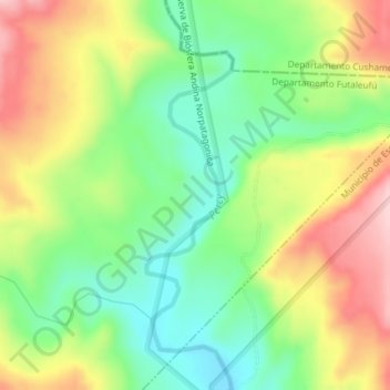
Name: Percy topographic map, elevation, terrain.
Location: Percy, Departamento Futaleufú, CHB, Argentina (-42.77801 -71.39421 -42.76073 -71.38621)
Average elevation: 917 m
Minimum elevation: 824 m
Maximum elevation: 1,038 m
Other topographic maps
Click on a map to view its topography, its elevation and its terrain.
Los Alerces National Park
Los Alerces National Park, Departamento Futaleufú, CHB, Argentina
Average elevation: 1,074 m