
Langnau topographic map
Interactive map
Click on the map to display elevation.
About this map
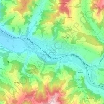
Name: Langnau topographic map, elevation, terrain.
Average elevation: 787 m
Minimum elevation: 650 m
Maximum elevation: 1,030 m
Other topographic maps
Click on a map to view its topography, its elevation and its terrain.
Chatzegrat
Schweiz > Bern > Verwaltungskreis Emmental > Langnau im Emmental > Bärau
Chatzegrat, Bärau, Langnau im Emmental, Verwaltungskreis Emmental, Verwaltungsregion Emmental-Oberaargau, Bern, 3552, Schweiz
Average elevation: 848 m