
Thank you for supporting this site ❤️
Make a donation
Make a donation
Grangemouth topographic map
Click on the map to display elevation.
Thank you for supporting this site ❤️
Make a donation
Make a donation
About this map
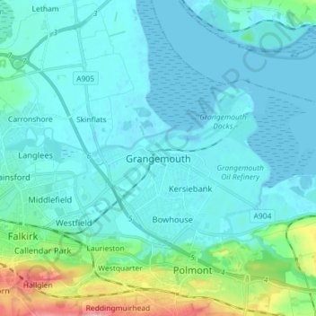
Name: Grangemouth topographic map, elevation, terrain.
Location: Grangemouth, Falkirk, Scotland, FK3 8BG, United Kingdom (55.97890 -3.76303 56.05890 -3.68303)
Average elevation: 19 m
Minimum elevation: -2 m
Maximum elevation: 135 m
Thank you for supporting this site ❤️
Make a donation
Make a donation