
Kolar district topographic map
Interactive map
Click on the map to display elevation.
About this map
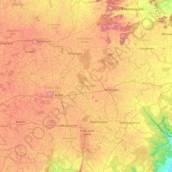
Name: Kolar district topographic map, elevation, terrain.
Location: Kolar district, Karnataka, India (12.76070 77.84100 13.59885 78.58808)
Average elevation: 796 m
Minimum elevation: 318 m
Maximum elevation: 1,316 m
Other topographic maps
Click on a map to view its topography, its elevation and its terrain.
Bengaluru
India > Karnataka > Bangalore North
Bangalore (/bæŋɡəˈlɔːr/), officially Bengaluru (Kannada pronunciation: [ˈbeŋgɐɭuːɾu] (listen)), is the capital and largest city of the Indian state of Karnataka. It has a population of more than 8 million and a metropolitan population of around 11 million, making it the third most populous city…
Average elevation: 881 m
Mangaluru
India > Karnataka > Mangaluru taluk
Mangalore is also the administrative headquarters of the Dakshina Kannada district; it is a commercial, industrial, educational, healthcare, and startup hub. The city's international airport is the second-largest and second-busiest airport in Karnataka. Mangalore City Corporation is responsible for the civic…
Average elevation: 25 m
Udupi
India > Karnataka > Udupi taluku
Udupi has an elevation of 27 m (89 ft) above mean sea level. The climate in Udupi is hot in summers and pleasant in winter. During summers (from March to May) the temperature reaches up to 38 °C (100 °F) and in winters (from December to February) it is usually between 32 and 20 °C (90 and 68 °F). As it is…
Average elevation: 17 m
Mysuru
India > Karnataka > Mysuru taluk
Mysore (/maɪˈsɔːr/ (listen)), officially Mysuru ([ˈmaɪˈsuːɾu] (listen)), is a city in the southern part of the state of Karnataka, India. Mysore city is geographically located between 12° 18′ 26″ north latitude and 76° 38′ 59″ east longitude. It is located at an altitude of 770 m (2,530 ft)…
Average elevation: 727 m
Kalaburagi
India > Karnataka > Kalaburagi taluku
The entire district is on the Deccan Plateau, and the elevation ranges from 300 to 750 m above MSL. Two main rivers, the Krishna and Bhima, flow through the district. The predominant soil type is black soil. The district has many tanks, which irrigate the land along with the river. The Upper Krishna Project is…
Average elevation: 465 m
Sindagi
India > Karnataka > Sindagi taluku
Sindagi is located at 16°55′N 76°14′E / 16.92°N 76.23°E / 16.92; 76.23. It has an average elevation of 500 metres (1640 feet). Sindagi is 60 km/37.28 miles away from the main district city of Bijapur, and 545 km/338.95 miles from the state capital, Bangalore. The nearest major railway station…
Average elevation: 504 m
Srinivaspur
India > Karnataka > Srinivasapura taluku
Srinivaspur is located at 13°20′N 78°13′E / 13.33°N 78.22°E / 13.33; 78.22. It has an average elevation of 819 metres (2,687 ft). The geographical area of the taluk is 860 square kilometres (330 sq mi).
Average elevation: 830 m