
Abenheim topographic map
Interactive map
Click on the map to display elevation.
About this map
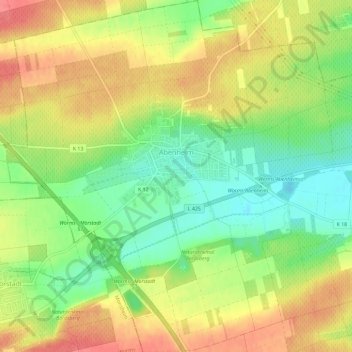
Name: Abenheim topographic map, elevation, terrain.
Average elevation: 126 m
Minimum elevation: 92 m
Maximum elevation: 158 m
Other topographic maps
Click on a map to view its topography, its elevation and its terrain.
Worms
Deutschland > Rheinland-Pfalz > Worms
Worms, Rheinland-Pfalz, 67547, Deutschland
Average elevation: 100 m
Weinsheim
Deutschland > Rheinland-Pfalz > Worms
Weinsheim, Vororte Südwest, Worms, Rheinland-Pfalz, Deutschland
Average elevation: 103 m
Worms-Nord
Deutschland > Rheinland-Pfalz > Worms
Worms-Nord, Stadtgebiet Nord, Worms, Rheinland-Pfalz, 67547, Deutschland, Barbarossaplatz
Average elevation: 94 m
Ibersheim
Deutschland > Rheinland-Pfalz > Worms
Ibersheim, Nördliche Vororte, Worms, Rheinland-Pfalz, Deutschland
Average elevation: 89 m
Pfeddersheim
Deutschland > Rheinland-Pfalz > Worms
Pfeddersheim, Westliche Außenbezirke, Worms, Rheinland-Pfalz, 67551, Deutschland
Average elevation: 138 m