
Parker topographic map
Interactive map
Click on the map to display elevation.
About this map
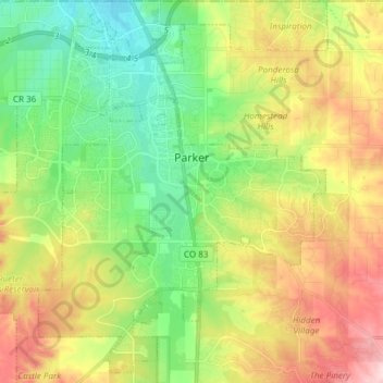
Name: Parker topographic map, elevation, terrain.
Location: Parker, Douglas County, Colorado, 80134, United States (39.45309 -104.82166 39.56590 -104.70849)
Average elevation: 1,846 m
Minimum elevation: 1,741 m
Maximum elevation: 2,004 m
Other topographic maps
Click on a map to view its topography, its elevation and its terrain.
Stonegate
United States > Colorado > Douglas County > Parker
Stonegate, Parker, Douglas County, Colorado, United States
Average elevation: 1,781 m