
Oberhavel topographic map
Interactive map
Click on the map to display elevation.
About this map
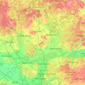
Name: Oberhavel topographic map, elevation, terrain.
Location: Oberhavel, Brandenburg, Deutschland (52.58660 12.82455 53.25103 13.52308)
Average elevation: 57 m
Minimum elevation: 22 m
Maximum elevation: 123 m
Other topographic maps
Click on a map to view its topography, its elevation and its terrain.
Hohenschöpping
Deutschland > Brandenburg > Oberhavel > Velten
Hohenschöpping, Velten, Oberhavel, Brandenburg, 16540, Deutschland
Average elevation: 38 m
Liebenwalde
Deutschland > Brandenburg > Oberhavel > Liebenwalde
Liebenwalde, Oberhavel, Brandenburg, 16559, Deutschland
Average elevation: 45 m