
Thank you for supporting this site ❤️
Make a donation
Make a donation
Gayle Mill topographic map
Click on the map to display elevation.
Thank you for supporting this site ❤️
Make a donation
Make a donation
About this map
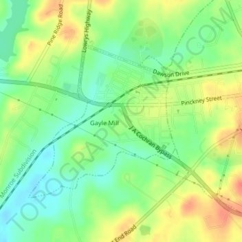
Name: Gayle Mill topographic map, elevation, terrain.
Location: Gayle Mill, Chester County, South Carolina, United States (34.69373 -81.25041 34.71076 -81.23044)
Average elevation: 143 m
Minimum elevation: 121 m
Maximum elevation: 170 m
Thank you for supporting this site ❤️
Make a donation
Make a donation
Other topographic maps
Click on a map to view its topography, its elevation and its terrain.