
Thank you for supporting this site ❤️
Make a donation
Make a donation
Cerro Negro topographic map
Click on the map to display elevation.
Thank you for supporting this site ❤️
Make a donation
Make a donation
About this map
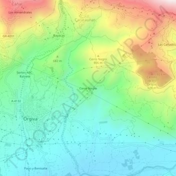
Name: Cerro Negro topographic map, elevation, terrain.
Average elevation: 594 m
Minimum elevation: 315 m
Maximum elevation: 1,164 m
Thank you for supporting this site ❤️
Make a donation
Make a donation
Other topographic maps
Click on a map to view its topography, its elevation and its terrain.
Sierra de Lújar
España > Andalucía > Comarca de la Alpujarra Granadina > Órgiva
Average elevation: 1,254 m