
Thank you for supporting this site ❤️
Make a donation
Make a donation
Howick topographic map
Click on the map to display elevation.
Thank you for supporting this site ❤️
Make a donation
Make a donation
About this map
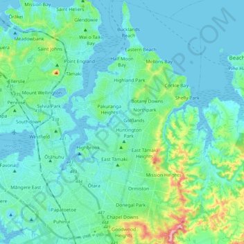
Name: Howick topographic map, elevation, terrain.
Location: Howick, Auckland, New Zealand (-37.00173 174.85646 -36.84578 174.96843)
Average elevation: 27 m
Minimum elevation: -1 m
Maximum elevation: 172 m
Thank you for supporting this site ❤️
Make a donation
Make a donation
Other topographic maps
Click on a map to view its topography, its elevation and its terrain.
Thank you for supporting this site ❤️
Make a donation
Make a donation
Thank you for supporting this site ❤️
Make a donation
Make a donation