
Comté de Baltimore topographic map
Interactive map
Click on the map to display elevation.
About this map
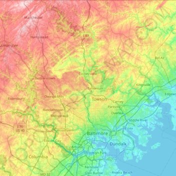
Name: Comté de Baltimore topographic map, elevation, terrain.
Location: Comté de Baltimore, Maryland, États-Unis d'Amérique (39.15168 -76.89656 39.72120 -76.27149)
Average elevation: 123 m
Minimum elevation: -3 m
Maximum elevation: 339 m
Other topographic maps
Click on a map to view its topography, its elevation and its terrain.
Owings Mills
États-Unis d'Amérique > Maryland > Comté de Baltimore
Owings Mills, Comté de Baltimore, Maryland, 21117, États-Unis d'Amérique
Average elevation: 173 m
Perry Hall
États-Unis d'Amérique > Maryland > Comté de Baltimore > Perry Hall
Perry Hall, Comté de Baltimore, Maryland, États-Unis d'Amérique
Average elevation: 73 m
Owings Mills
États-Unis d'Amérique > Maryland > Comté de Baltimore > Owings Mills
Owings Mills, Comté de Baltimore, Maryland, 21117, États-Unis d'Amérique
Average elevation: 173 m
Towson
États-Unis d'Amérique > Maryland > Comté de Baltimore > Towson
Towson, Comté de Baltimore, Maryland, États-Unis d'Amérique
Average elevation: 114 m