
Tharandt topographic map
Interactive map
Click on the map to display elevation.
About this map
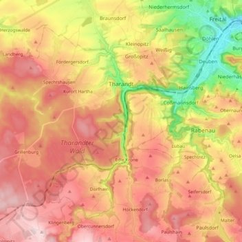
Name: Tharandt topographic map, elevation, terrain.
Average elevation: 340 m
Minimum elevation: 157 m
Maximum elevation: 479 m
Other topographic maps
Click on a map to view its topography, its elevation and its terrain.
Blauberg
Duitsland > Saksen > Sächsische Schweiz-Osterzgebirge > Dohna
Blauberg, Dohna, Dohna-Müglitztal, Sächsische Schweiz-Osterzgebirge, Saksen, 01731, Duitsland
Average elevation: 238 m
Rabenau
Duitsland > Saksen > Sächsische Schweiz-Osterzgebirge > Rabenau
Rabenau, Sächsische Schweiz-Osterzgebirge, Saksen, 01734, Duitsland
Average elevation: 342 m
Bad Schandau
Duitsland > Saksen > Sächsische Schweiz-Osterzgebirge
Bad Schandau, Sächsische Schweiz-Osterzgebirge, Saksen, 01814, Duitsland
Average elevation: 301 m