
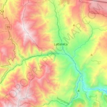
Labateca topographic map
Interactive map
Click on the map to display elevation.
About this map
Name: Labateca topographic map, elevation, terrain.
Average elevation: 2,240 m
Minimum elevation: 964 m
Maximum elevation: 3,684 m
Other topographic maps
Click on a map to view its topography, its elevation and its terrain.
Cúcuta
Colombia > Norte de Santander > Cúcuta
Cúcuta, Norte de Santander, 047, Colombia
Average elevation: 575 m
La Palmita
Colombia > Norte de Santander > Ocaña > Ocaña
La Palmita, Ocaña, Occidente, Norte de Santander, RAP Gran Santander, 546552, Colombia
Average elevation: 1,267 m
Pamplona
Pamplona, Suroccidente, Norte de Santander, RAP Gran Santander, Colombia
Average elevation: 2,572 m
Cúcuta
Cúcuta, Oriental, Norte de Santander, RAP Gran Santander, Colombia
Average elevation: 591 m
Río Culagá
Colombia > Norte de Santander > Labateca
Río Culagá, Labateca, Suroriente, Norte de Santander, RAP Gran Santander, Colombia
Average elevation: 2,123 m
Río Cáraba
Colombia > Norte de Santander > Silos
Río Cáraba, Silos, Suroccidente, Norte de Santander, RAP Gran Santander, Colombia
Average elevation: 3,391 m
Ocaña
Ocaña, Occidente, Norte de Santander, RAP Gran Santander, Colombia
Average elevation: 720 m
La Donjuana
Colombia > Norte de Santander > Bochalema
La Donjuana, Bochalema, Suroriente, Norte de Santander, RAP Gran Santander, Colombia
Average elevation: 951 m
La San Juana
Colombia > Norte de Santander > Sardinata > Bucarasica
La San Juana, Bucarasica, Sardinata, Norte, Norte de Santander, RAP Gran Santander, Colombia
Average elevation: 628 m
El Carmen
El Carmen, Occidente, Norte de Santander, RAP Gran Santander, Colombia
Average elevation: 528 m
La Laguna
Colombia > Norte de Santander > Salazar
La Laguna, Salazar, Centro, Norte de Santander, RAP Gran Santander, Colombia
Average elevation: 874 m
Chitagá
Chitagá, Suroccidente, Norte de Santander, Colombia
Average elevation: 3,002 m
Juan Frio
Colombia > Norte de Santander > Villa del Rosario
Juan Frio, Villa del Rosario, Oriental, Norte de Santander, RAP Gran Santander, Colombia
Average elevation: 501 m
Chinácota
Chinácota, Suroriente, Norte de Santander, RAP Gran Santander, Colombia
Average elevation: 1,794 m
Tibú
Colombia > Norte de Santander > Tibú
Tibú, Norte, Norte de Santander, Región Andina, Colombia
Average elevation: 440 m
San Pedro
Colombia > Norte de Santander > Toledo
San Pedro, Toledo, Suroriente, Norte de Santander, RAP Gran Santander, Colombia
Average elevation: 1,567 m
Luz Polar
Colombia > Norte de Santander > Ocaña > Ocaña
Luz Polar, Ocaña, Occidente, Norte de Santander, RAP Gran Santander, 546552, Colombia
Average elevation: 1,275 m
Laguna El Cacique Cácota
Colombia > Norte de Santander > Cácota
Laguna El Cacique Cácota, Cácota, Suroccidente, Norte de Santander, RAP Gran Santander, Colombia
Average elevation: 2,851 m
Villa Mar
Colombia > Norte de Santander > Ocaña > Ocaña
Villa Mar, Ocaña, Occidente, Norte de Santander, RAP Gran Santander, 546551, Colombia
Average elevation: 1,186 m
Vereda La Paz
Colombia > Norte de Santander > El Tarra
Vereda La Paz, Corregimiento Filogringo, El Tarra, Norte, Norte de Santander, Colombia
Average elevation: 396 m
Abrego
Abrego, Occidente, Norte de Santander, RAP Gran Santander, Colombia
Average elevation: 1,557 m
Páramo de Santurbán
Páramo de Santurbán, Centro, Norte de Santander, RAP Gran Santander, Colombia
Average elevation: 2,843 m
Páramo de Santurbán
Páramo de Santurbán, Mutiscua, Norte de Santander, Colombia
Average elevation: 3,340 m
Bochalema
Bochalema, Suroriente, Norte de Santander, RAP Gran Santander, Colombia
Average elevation: 1,395 m
Corregimiento El Paso
Colombia > Norte de Santander > El Tarra
Corregimiento El Paso, El Tarra, Norte, Norte de Santander, Colombia
Average elevation: 707 m
El Tarra
El Tarra, Norte, Norte de Santander, RAP Gran Santander, Colombia
Average elevation: 548 m
Perímetro Urbano Cúcuta
Perímetro Urbano Cúcuta, Cúcuta, Oriental, Norte de Santander, RAP Gran Santander, Colombia
Average elevation: 314 m
Zulia
Colombia > Norte de Santander > Salazar
Zulia, Salazar, Centro, Norte de Santander, RAP Gran Santander, Colombia
Average elevation: 1,000 m
La Playa de Belén
La Playa de Belén, Occidente, Norte de Santander, RAP Gran Santander, Colombia
Average elevation: 1,488 m
Tibú
Tibú, Norte, Norte de Santander, RAP Gran Santander, Colombia
Average elevation: 462 m
Los Patios
Los Patios, Oriental, Norte de Santander, RAP Gran Santander, Colombia
Average elevation: 842 m
Toledo
Toledo, Suroriente, Norte de Santander, RAP Gran Santander, Colombia
Average elevation: 2,367 m
Gramalote
Gramalote, Centro, Norte de Santander, RAP Gran Santander, Colombia
Average elevation: 1,261 m
Ragonvalia
Ragonvalia, Suroriente, Norte de Santander, Colombia
Average elevation: 1,778 m
Icota
Colombia > Norte de Santander > Chitagá
Icota, Chitagá, Suroccidente, Norte de Santander, Colombia
Average elevation: 2,402 m
Herrán
Herrán, Suroriente, Norte de Santander, Colombia
Average elevation: 2,398 m
Sardinata
Sardinata, Norte, Norte de Santander, Colombia
Average elevation: 929 m
Lourdes
Lourdes, Centro, Norte de Santander, Colombia
Average elevation: 1,505 m
Pachelli
Pachelli, Norte, Norte de Santander, Colombia
Average elevation: 329 m
canal de aguas lluvias
Colombia > Norte de Santander > Cúcuta > Perímetro Urbano Cúcuta
canal de aguas lluvias, Carlos Garcia Lozada, Comuna 6 - Norte, Perímetro Urbano Cúcuta, Cúcuta, Oriental, Norte de Santander, RAP Gran Santander, 540002, Colombia
Average elevation: 305 m
Pamplonita
Pamplonita, Suroccidente, Norte de Santander, RAP Gran Santander, Colombia
Average elevation: 2,189 m
Villa del Rosario
Villa del Rosario, Oriental, Norte de Santander, 541030, Colombia
Average elevation: 841 m
Puerto Santander
Puerto Santander, Oriental, Norte de Santander, RAP Gran Santander, Colombia
Average elevation: 55 m
Paramo de Santurbán
Colombia > Norte de Santander > Silos
Paramo de Santurbán, Silos, Suroccidente, Norte de Santander, Colombia
Average elevation: 3,669 m
Hacarí
Hacarí, Occidente, Norte de Santander, RAP Gran Santander, Colombia
Average elevation: 666 m
Convención
Convención, Occidente, Norte de Santander, RAP Gran Santander, Colombia
Average elevation: 545 m
Puerto Villamizar
Colombia > Norte de Santander > Cúcuta
Puerto Villamizar, Cúcuta, Oriental, Norte de Santander, Colombia
Average elevation: 56 m
Ocaña
Colombia > Norte de Santander > Ocaña
Ocaña, Occidente, Norte de Santander, Colombia
Average elevation: 1,160 m
Los Peracos
Colombia > Norte de Santander > Cúcuta
Los Peracos, Cúcuta, Oriental, Norte de Santander, 540002, Colombia
Average elevation: 313 m