
Make a donation
Dickschied topographic map
Click on the map to display elevation.
Make a donation
About this map
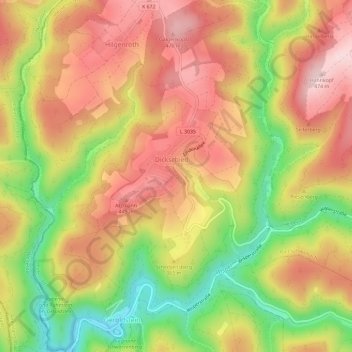
Name: Dickschied topographic map, elevation, terrain.
Average elevation: 353 m
Minimum elevation: 201 m
Maximum elevation: 471 m
Make a donation
Other topographic maps
Click on a map to view its topography, its elevation and its terrain.
Watzelhain
Deutschland > Hessen > Rheingau-Taunus-Kreis
Watzelhain liegt südlich von Kemel auf einem in Nord-Süd-Richtung gestreckten Höhenrücken, der zum Westlichen Aartaunus gehört, hoch über dem Dornbach II im Westen, dem Dornbach im Süden und dem Aulbach im Osten. Der Dornbach führt diese Gewässer nach Westen der Wisper zu. Der Ort ist umgeben von…
Average elevation: 430 m
Burg Schwarzenstein
Deutschland > Hessen > Rheingau-Taunus-Kreis > Johannisberg
Die Burg Schwarzenstein liegt bei Geisenheim auf 212 m ü. NHN unterhalb des Johannisberger Stadtteils Schloßheide an der Straße nach Stephanshausen. Sie wurde als historisierende künstliche Ruine einer Höhenburg erbaut.
Average elevation: 202 m
Make a donation
Burg Hohenstein
Deutschland > Hessen > Rheingau-Taunus-Kreis > Hohenstein > Burg Hohenstein
Average elevation: 338 m
Kalte Herberge
Deutschland > Hessen > Rheingau-Taunus-Kreis > Oestrich-Winkel
Blick von Bubenhäuser Höhe bei Eltville nach Westnordwesten auf Hallgarter Zange, Kalte Herberge und Erbacher Kopf
Average elevation: 518 m
Make a donation
Hohe Wurzel
Deutschland > Hessen > Rheingau-Taunus-Kreis
Die Hohe Wurzel liegt im Naturpark Rhein-Taunus. Während sich ihr größter Teil einschließlich der Gipfelregion in der Gemarkung des Taunussteiner Stadtteils Bleidenstadt befindet, zählen ihre südöstlichen Teile, die sich unterhalb des Rheinhöhenweges befinden, zum Ortsbezirk Dotzheim der Stadt…
Average elevation: 509 m
Zorn
Deutschland > Hessen > Rheingau-Taunus-Kreis
Zorn liegt im westlichen Hintertaunus auf einer Hochebene, der Zorner Hochfläche, und im Quellgebiet von Morsbach und Busebach an der Landesgrenze zu Rheinland-Pfalz. Die Zorner Hochfläche ist im Nordosten mit dem quer dazu laufenden Höhenzug der Kemeler Heide verbunden und bildet die Wasserscheide zwischen…
Average elevation: 430 m
Niederseelbach
Deutschland > Hessen > Rheingau-Taunus-Kreis > Niedernhausen
Die Gemarkung reicht im Norden bis zu einem Kilometer über die Wasserscheide hinaus. Der südlichste Punkt ist zugleich der höchste Punkt der Gemarkung. Er liegt auf dem Zieglerkopf, dem Ostausläufer der Hohen Kanzel, in 515 Meter Höhe.
Average elevation: 387 m
Make a donation
Laufenselden
Deutschland > Hessen > Rheingau-Taunus-Kreis
Drei Kilometer westlich von Laufenselden erhebt sich der Graue Kopf, mit 543 m ü. NN, der zweithöchste Berg im westlichen Hintertaunus. Dieser Höhenzug zieht sich in nordöstliche Richtung und dacht sich zum Hahnkopf (429 m ü. NN), als letzten Ausläufer, ab. Südwestlich des Ortes erhebt sich der…
Average elevation: 415 m
Teufelskadrich
Deutschland > Hessen > Rheingau-Taunus-Kreis > Rüdesheim am Rhein > Aulhausen
Average elevation: 285 m
Make a donation
Heftrich
Deutschland > Hessen > Rheingau-Taunus-Kreis > Idstein
Heftrich liegt östlich der Kernstadt Idstein in einer Talmulde im Quellgebiet des Schlabachs, einem linken südlichen Zufluss des Emsbachs bei Esch, an der Wasserscheide zwischen Lahn und Main im östlichen Hintertaunus. Auf dieser Wasserscheide im Süden der Gemarkung verläuft der Römische Limes. Hier…
Average elevation: 358 m
Gaisgarten
Deutschland > Hessen > Rheingau-Taunus-Kreis > Eltville am Rhein > Hattenheim > Gaisgarten
Average elevation: 323 m
Make a donation