
Make a donation
Lagoa topographic map
Click on the map to display elevation.
Make a donation
Lagoa
From the 1960s, however, tourism increasingly became the main driver of the area's economic development and creation of brand new infrastructure. This has brought an increase in job creation, its growth rapidly became the economic engine of the municipality, and it has now assumed a prominent place in the local economy. In parallel to the growth of tourism, the growth of all the related activities, especially in the construction industry, services, and commerce in general, resulted in the elevation of Lagoa to the status of city (cidade).
Make a donation
About this map
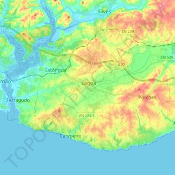
Name: Lagoa topographic map, elevation, terrain.
Location: Lagoa, Faro, Portugal (37.08533 -8.53241 37.17988 -8.36930)
Average elevation: 34 m
Minimum elevation: -8 m
Maximum elevation: 116 m
Make a donation
Other topographic maps
Click on a map to view its topography, its elevation and its terrain.