
Karlskoga topographic map
Interactive map
Click on the map to display elevation.
About this map
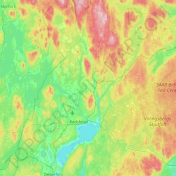
Name: Karlskoga topographic map, elevation, terrain.
Location: Karlskoga, Örebro County, Region Svealand, Sweden (59.23245 14.32624 59.54224 14.78992)
Average elevation: 165 m
Minimum elevation: 87 m
Maximum elevation: 319 m
Other topographic maps
Click on a map to view its topography, its elevation and its terrain.
Tomtabacken
Sweden > Örebro County > Blåberga
Tomtabacken, Blåberga, Hallsberg, Province Närke, Örebro County, Region Svealand, 69491, Sweden
Average elevation: 72 m