
Make a donation
Münchenberg topographic map
Click on the map to display elevation.
Make a donation
About this map
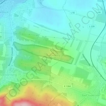
Name: Münchenberg topographic map, elevation, terrain.
Average elevation: 194 m
Minimum elevation: 138 m
Maximum elevation: 350 m
Make a donation
Other topographic maps
Click on a map to view its topography, its elevation and its terrain.
Friedrichsbrunn
Deutschland > Sachsen-Anhalt > Landkreis Harz > Thale
Die touristische Entwicklung begann im Jahr 1884, als die ersten Sommergäste ihren Urlaub in diesem Ort verbrachten. Zum Höhenluftkurort ernannt, wurden noch vor dem Ersten Weltkrieg in Friedrichsbrunn zwei Sanatorien, drei größere Hotels und zahlreiche kleinere Pensionen errichtet. In der Zeit der…
Average elevation: 468 m
Neinstedt
Deutschland > Sachsen-Anhalt > Landkreis Harz > Thale
Durch den Ort hindurch führt die Landesstraße 92. Seit 1997 bestand die Absicht, eine Ortsumfahrung für Neinstedt zu realisieren, auch um den Menschen der Evangelischen Stiftung Neinstedt zusätzliche Sicherheit zu geben. Zunächst wurde durch die Stiftung eine Fußgängerunterführung unter der L92 erbaut,…
Average elevation: 162 m
Make a donation
Treseburg
Deutschland > Sachsen-Anhalt > Landkreis Harz > Thale
Unterhalb von Treseburg (flussabwärts) liegt das Naturschutzgebiet Bodetal, durch das ein etwa zehn Kilometer langer Wanderweg nach Thale bzw. zur Roßtrappe führt. Ein weiterer Wanderweg geht von dort aus über die Höhen und die Klippe Weißer Hirsch zum Hexentanzplatz. Ferner beginnt bzw. endet hier der…
Average elevation: 404 m
Bodetal
Deutschland > Sachsen-Anhalt > Landkreis Harz > Thale
Ein zehn Kilometer langer Wanderweg erschließt die Bodeschlucht zwischen Thale und Treseburg. An Engstellen wird der Weg in steilen Kehren und als Fußpfad über Felsen geführt. Von dort ergeben sich hervorragende Ausblicke in die Schlucht. Zuwegungen ins Tal gehen von den Aussichtsfelsen an Roßtrappe und…
Average elevation: 390 m
Stecklenberg
Deutschland > Sachsen-Anhalt > Landkreis Harz > Thale
Stecklenberg entstand am Fuße der Stecklenburg und der etwas höher gelegenen Lauenburg. Beide Burgen sind heute Ruinen und können als solche besichtigt werden. Der Ort war Sitz eines eigenen Amtes, das 1815 an den Regierungsbezirk Magdeburg der preußischen Provinz Sachsen gelangte. Aufgrund der…
Average elevation: 275 m
Make a donation
Weddersleben
Deutschland > Sachsen-Anhalt > Landkreis Harz > Thale
In Weddersleben befand sich eine jungbronzezeitliche Höhensiedlung.
Average elevation: 152 m