
Thank you for supporting this site ❤️
Make a donation
Make a donation
Nonières topographic map
Click on the map to display elevation.
Thank you for supporting this site ❤️
Make a donation
Make a donation
About this map
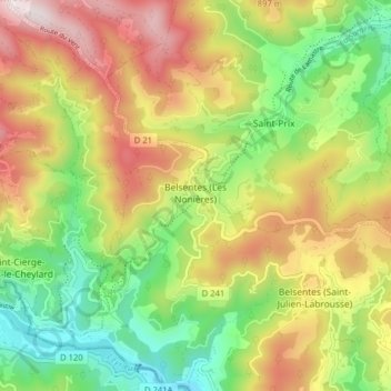
Name: Nonières topographic map, elevation, terrain.
Average elevation: 693 m
Minimum elevation: 381 m
Maximum elevation: 1,081 m
Thank you for supporting this site ❤️
Make a donation
Make a donation
Other topographic maps
Click on a map to view its topography, its elevation and its terrain.
Le Serre
France > Auvergne-Rhône-Alpes > Ardèche > Belsentes > Saint-Julien-Labrousse
Average elevation: 554 m
Belsentes (Les Nonières)
France > Auvergne-Rhône-Alpes > Ardèche > Belsentes > Belsentes (Les Nonières)
Average elevation: 698 m