
Thank you for supporting this site ❤️
Make a donation
Make a donation
Bouhachana topographic map
Click on the map to display elevation.
Thank you for supporting this site ❤️
Make a donation
Make a donation
About this map
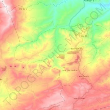
Name: Bouhachana topographic map, elevation, terrain.
Location: Bouhachana, Khezara District, Guelma, Algeria (36.25839 7.41045 36.33814 7.58443)
Average elevation: 841 m
Minimum elevation: 273 m
Maximum elevation: 1,400 m
Thank you for supporting this site ❤️
Make a donation
Make a donation