
Datong topographic map
Click on the map to display elevation.
About this map
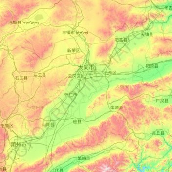
Name: Datong topographic map, elevation, terrain.
Location: Datong, Shanxi, China (39.04845 112.57067 40.74496 114.56551)
Average elevation: 1,339 m
Minimum elevation: 690 m
Maximum elevation: 3,029 m
Other topographic maps
Click on a map to view its topography, its elevation and its terrain.
Changzhi
China > Shanxi > Changzhi > Yingxiongnanlu Subdistrict
Changzhi is located in southeastern Shanxi province, along the southern section of the Taihang Mountains. The majority of the city's area is mountainous, and much of the remaining geography is hilly in nature. The average elevation in the city is approximately 1,000 metres (3,300 ft) above sea level, with…
Average elevation: 986 m
Huozhou
China > Shanxi > Huozhou City > Beihuanlu Subdistrict
The city's altitude ranges from 516 to 2,504.3 m (1,693 to 8,216 ft) in height. The Fen River runs through the city from north to south.
Average elevation: 908 m