
Thank you for supporting this site ❤️
Make a donation
Make a donation
Mukkali topographic map
Click on the map to display elevation.
Thank you for supporting this site ❤️
Make a donation
Make a donation
About this map
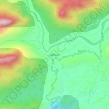
Name: Mukkali topographic map, elevation, terrain.
Location: Mukkali, Mannarkad, Palakkad District, Kerala, India (11.04443 76.52006 11.08443 76.56006)
Average elevation: 618 m
Minimum elevation: 376 m
Maximum elevation: 1,076 m
Thank you for supporting this site ❤️
Make a donation
Make a donation
Other topographic maps
Click on a map to view its topography, its elevation and its terrain.