
Urdaneta topographic map
Interactive map
Click on the map to display elevation.
About this map
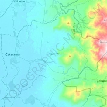
Name: Urdaneta topographic map, elevation, terrain.
Location: Urdaneta, Los Ríos, 1, Ecuador (-1.67408 -79.50223 -1.46081 -79.24592)
Average elevation: 198 m
Minimum elevation: 5 m
Maximum elevation: 1,492 m
Other topographic maps
Click on a map to view its topography, its elevation and its terrain.
La Chorrera
Ecuador > Los Ríos > La Chorrera
La Chorrera, Parroquia Pimocha, Babahoyo, Los Ríos, EC120150, Ecuador
Average elevation: 7 m