
Thank you for supporting this site ❤️
Make a donation
Make a donation
Angeles National Forest topographic map
Click on the map to display elevation.
Thank you for supporting this site ❤️
Make a donation
Make a donation
Angeles National Forest
The Angeles National Forest manages the habitats, flora and fauna ecosystems, and watersheds. Some of the rivers with watersheds within its boundaries provide valuable non-groundwater recharge water for Southern California. The existing protected and restored native vegetation absorb and slow surface runoff of rainwater to minimize severe floods and landslides in adjacent communities. The land within the forest is diverse, both in appearance and terrain. Elevations range from 1,200 to 10,064 ft (366 to 3,068 m). The Pacific Crest Trail crosses the forest.
Thank you for supporting this site ❤️
Make a donation
Make a donation
About this map
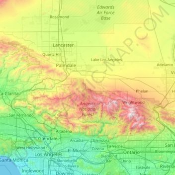
Name: Angeles National Forest topographic map, elevation, terrain.
Average elevation: 782 m
Minimum elevation: 0 m
Maximum elevation: 3,046 m
Thank you for supporting this site ❤️
Make a donation
Make a donation