
Thank you for supporting this site ❤️
Make a donation
Make a donation
Meremere topographic map
Click on the map to display elevation.
Thank you for supporting this site ❤️
Make a donation
Make a donation
About this map
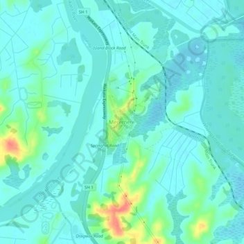
Name: Meremere topographic map, elevation, terrain.
Location: Meremere, Waikato District, Waikato, 2474, New Zealand (-37.34052 175.04990 -37.30052 175.08990)
Average elevation: 14 m
Minimum elevation: 2 m
Maximum elevation: 63 m
Thank you for supporting this site ❤️
Make a donation
Make a donation
Other topographic maps
Click on a map to view its topography, its elevation and its terrain.