
Nyaung-U Township topographic map
Interactive map
Click on the map to display elevation.
About this map
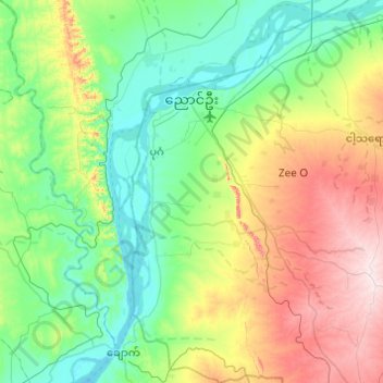
Name: Nyaung-U Township topographic map, elevation, terrain.
Location: Nyaung-U Township, Nyaung-U District, Mandalay, Myanmar (20.85843 94.82973 21.31370 95.23200)
Average elevation: 178 m
Minimum elevation: 43 m
Maximum elevation: 517 m
Other topographic maps
Click on a map to view its topography, its elevation and its terrain.
Tha But Kone
Myanmar > Mandalay > Wundwin Township
Tha But Kone, Wundwin Township, Meiktila District, Mandalay, Myanmar
Average elevation: 141 m
Kyaukpadaung Township
Kyaukpadaung Township, Nyaung-U District, Mandalay, 05241, Myanmar
Average elevation: 296 m
Sintgaing Township
Myanmar > Mandalay > Kyaukse District
Sintgaing Township, Kyaukse District, Mandalay, Myanmar
Average elevation: 104 m
Bagan
Myanmar > Mandalay > Nyaung-U District > Nyaung-U Township
Bagan, Nyaung-U Township, Nyaung-U District, Mandalay, 55000, Myanmar
Average elevation: 70 m
Pyawbwe Township
Myanmar > Mandalay > Yamethin District
Pyawbwe Township, Yamethin District, Mandalay, Myanmar
Average elevation: 336 m
Pyinoolwin Township
Myanmar > Mandalay > Pyinoolwin Township
Pyinoolwin Township, Pyin Oo Lwin District, Mandalay, 05081, Myanmar
Average elevation: 597 m