
Thank you for supporting this site ❤️
Make a donation
Make a donation
Wyoming topographic map
Click on the map to display elevation.
Thank you for supporting this site ❤️
Make a donation
Make a donation
About this map
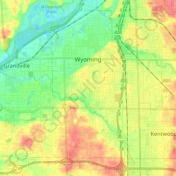
Name: Wyoming topographic map, elevation, terrain.
Location: Wyoming, Kent County, Michigan, United States (42.85038 -85.78234 42.94221 -85.64113)
Average elevation: 204 m
Minimum elevation: 178 m
Maximum elevation: 236 m
Thank you for supporting this site ❤️
Make a donation
Make a donation
Other topographic maps
Click on a map to view its topography, its elevation and its terrain.
Echo Lake
United States > Michigan > Kent County > Grand Rapids Charter Township
Average elevation: 240 m
Thank you for supporting this site ❤️
Make a donation
Make a donation
Thank you for supporting this site ❤️
Make a donation
Make a donation
Thank you for supporting this site ❤️
Make a donation
Make a donation