
Hütten topographic map
Interactive map
Click on the map to display elevation.
About this map
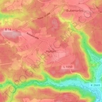
Name: Hütten topographic map, elevation, terrain.
Average elevation: 464 m
Minimum elevation: 376 m
Maximum elevation: 507 m
Other topographic maps
Click on a map to view its topography, its elevation and its terrain.
Langenburg
Deutschland > Baden-Württemberg > Landkreis Schwäbisch Hall > Langenburg
Langenburg, Verwaltungsgemeinschaft Gerabronn, Landkreis Schwäbisch Hall, Baden-Württemberg, 74595, Deutschland
Average elevation: 432 m
Rot am See
Deutschland > Baden-Württemberg > Landkreis Schwäbisch Hall > Rot am See
Rot am See, Verwaltungsverband Brettach/Jagst, Landkreis Schwäbisch Hall, Baden-Württemberg, 74585, Deutschland
Average elevation: 450 m
Braunsbach
Deutschland > Baden-Württemberg > Landkreis Schwäbisch Hall
Braunsbach, Verwaltungsverband Braunsbach-Untermünkheim, Landkreis Schwäbisch Hall, Baden-Württemberg, 74542, Deutschland
Average elevation: 397 m