
Make a donation
Fort Garland topographic map
Click on the map to display elevation.
Make a donation
Fort Garland
Fort Garland is located at an elevation of 7,936 ft (2,419 m) in northern Costilla County. Fort Garland is at the crossroads of U.S. Route 160 and Colorado State Highway 159, which leads south towards Taos and Santa Fe, New Mexico. The town of Blanca is 4 miles (6.4 km) west on U.S. Route 160. Walsenburg is 47 miles (76 km) to the east, across the Sangre de Cristo Range.
Make a donation
About this map
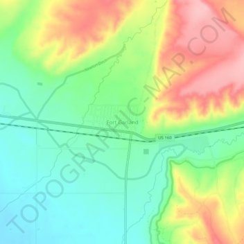
Name: Fort Garland topographic map, elevation, terrain.
Average elevation: 2,441 m
Minimum elevation: 2,380 m
Maximum elevation: 2,530 m
Make a donation
Other topographic maps
Click on a map to view its topography, its elevation and its terrain.
Fort Garland
United States > Colorado > Costilla County > Fort Garland
Fort Garland is located at an elevation of 7,936 ft (2,419 m) in northern Costilla County. Fort Garland is at the crossroads of U.S. Route 160 and Colorado State Highway 159, which leads south towards Taos and Santa Fe, New Mexico. The town of Blanca is 4 miles (6.4 km) west on U.S. Route 160. Walsenburg is 47…
Average elevation: 2,427 m